![](/images/other/stat-length.png)
![Randonnée Marche Cortina d'Ampezzo - Tofana di Rozes et refuge Giussani - Photo](https://media.geolcdn.com/t/1900/400/24a311db-b1cc-43f9-a2a4-f7e459ac5a29.jpg&format=pjpeg&maxdim=2)
Tofana di Rozes et refuge Giussani
GuyVachet
Utilisateur
![Longueur](/images/other/stat-length.png)
![Altitude max](https://static1.geolcdn.com/siteimages/upload/files/1508320355ic_sort_altitude_max_24dp.png)
![Dénivelé positif](https://static1.geolcdn.com/siteimages/upload/files/1508320355ic_sort_den_pos_24dp.png)
![Km-Effort](/images/other/stat-length.png)
![Altitude min](https://static1.geolcdn.com/siteimages/upload/files/1508320355ic_sort_altitude_min_24dp.png)
![Dénivelé négatif](https://static1.geolcdn.com/siteimages/upload/files/1508320355ic_sort_den_neg_24dp.png)
![Boucle](https://static1.geolcdn.com/siteimages/upload/files/16400158638029165_repeat_loop_refresh_sync_direction_icon.png)
![Marche](https://static1.geolcdn.com/sitytour/trail-icons/101.png)
4h49
Difficulté : Très difficile
![Scannez ce code QR pour ouvrir la randonnée dans l'application SityTrail](https://capi.geolives.com/qq0zvz2zws4bq2lad0pu/sitytour/trails/3805185/qr.png?size=200)
Application GPS de randonnée GRATUITE
À propos
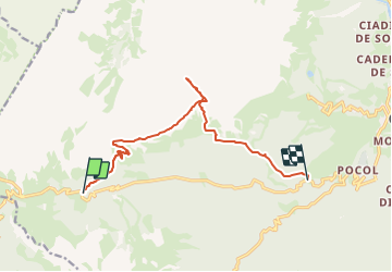
Randonnée Marche de 11,1 km à découvrir à Vénétie, Belluno, Cortina d'Ampezzo. Cette randonnée est proposée par GuyVachet.
Description
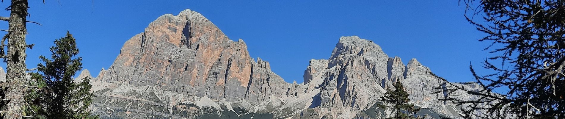
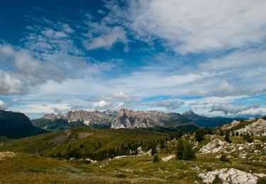
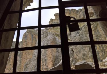
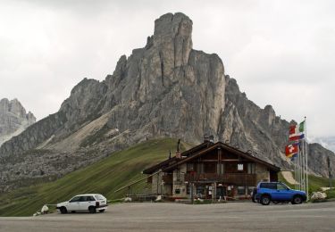
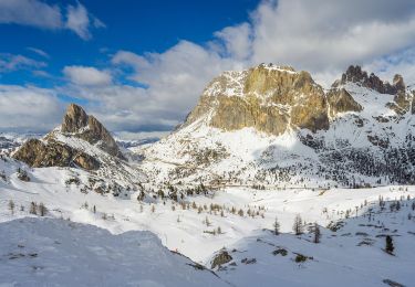
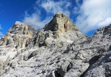
Traversée au pied de la somptueuse Tofana di Rozes pour atteindre le refuge Giussani. Au départ à Ra Nona, le parcours commence dans les mélèzes pour rejoindre un large chemin empierré avec une belle vue sur Croda da Lago, Cinque Torri et Averau. La traversée au pied de Tofana (que l'on peut voir dans les randos du lac Fédéra ou de la boucle Averau-Cinque Torri) permet d'apprécier la paroi mais elle mérite de l'attention au moins à 3 passages. Par la suite, un grand nombre de lames rocheuses se révèlent à la montée au refuge Giussani qui vaut bien la visite. La descente se fait bien par un large chemin qui passe par le refuge Dibona et arrive à Sol dei Prade où l'on aura pris la précaution de déposer un autre véhicule.
Localisation
Commentaires
Randonnées à proximité
![Randonnée A pied Cortina d'Ampezzo - 403 - Photo](https://media.geolcdn.com/t/375/260/e7a83c3c-599b-4c26-80e4-b96ec23a2e5a.jpeg&format=jpg&maxdim=2)
![A pied A pied](https://static1.geolcdn.com/sitytour/trail-icons/100.png)
![Randonnée A pied Cortina d'Ampezzo - (SI B04) Forcella Travenanzes (Bivio Lagazuoi) - Albergo Rifugio Ospitale - Photo](https://media.geolcdn.com/t/375/260/807c89f7-3651-49c4-a169-3e5c5dabc61a.jpeg&format=jpg&maxdim=2)
![A pied A pied](https://static1.geolcdn.com/sitytour/trail-icons/100.png)
A pied
![](/images/other/stat-length.png)
![](https://static1.geolcdn.com/siteimages/upload/files/16400158638029165_repeat_loop_refresh_sync_direction_icon.png)
![Randonnée A pied Livinallongo del Col di Lana - IT-24 - Photo](https://media.geolcdn.com/t/375/260/cbccd70f-0a82-410f-9410-491e2acdf170.jpeg&format=jpg&maxdim=2)
![A pied A pied](https://static1.geolcdn.com/sitytour/trail-icons/100.png)
A pied
![](/images/other/stat-length.png)
![](https://static1.geolcdn.com/siteimages/upload/files/16400158638029165_repeat_loop_refresh_sync_direction_icon.png)
![Randonnée A pied San Vito di Cadore - P.te del Moro Frates Mondeval Giau - Photo](https://media.geolcdn.com/t/375/260/d9b027c7-b025-4dc6-be94-19be041ceaf9.jpeg&format=jpg&maxdim=2)
![A pied A pied](https://static1.geolcdn.com/sitytour/trail-icons/100.png)
A pied
![](/images/other/stat-length.png)
![](https://static1.geolcdn.com/siteimages/upload/files/16400158638029165_repeat_loop_refresh_sync_direction_icon.png)
![Randonnée A pied Cortina d'Ampezzo - IT-424 - Photo](https://media.geolcdn.com/t/375/260/3ac0fb9f-8001-4b96-b838-ad9c3c46c7d5.jpeg&format=jpg&maxdim=2)
![A pied A pied](https://static1.geolcdn.com/sitytour/trail-icons/100.png)
![Randonnée A pied San Vito di Cadore - IT-443 - Photo](https://media.geolcdn.com/t/375/260/2347239d-b3f0-4c8e-852b-0f70ac5a7a5f.jpeg&format=jpg&maxdim=2)
![A pied A pied](https://static1.geolcdn.com/sitytour/trail-icons/100.png)
A pied
![](/images/other/stat-length.png)
![](https://static1.geolcdn.com/siteimages/upload/files/16400158638029165_repeat_loop_refresh_sync_direction_icon.png)
![Randonnée A pied Cortina d'Ampezzo - IT-441 - Photo](https://media.geolcdn.com/t/375/260/801a35dc-07c8-497e-9fca-c5a6b78bfc3e.jpeg&format=jpg&maxdim=2)
![A pied A pied](https://static1.geolcdn.com/sitytour/trail-icons/100.png)
![Randonnée A pied Cortina d'Ampezzo - IT-437 - Photo](https://media.geolcdn.com/t/375/260/48cea904-9dcf-43fa-b76f-0dc6d1296098.jpeg&format=jpg&maxdim=2)
![A pied A pied](https://static1.geolcdn.com/sitytour/trail-icons/100.png)
A pied
![](/images/other/stat-length.png)
![](https://static1.geolcdn.com/siteimages/upload/files/16400158638029165_repeat_loop_refresh_sync_direction_icon.png)
![Randonnée A pied Cortina d'Ampezzo - IT-412 - Photo](https://media.geolcdn.com/t/375/260/a25f4ac4-41bc-4fef-8c1c-419f6d0ff615.jpeg&format=jpg&maxdim=2)
![A pied A pied](https://static1.geolcdn.com/sitytour/trail-icons/100.png)
A pied
![](/images/other/stat-length.png)
![](https://static1.geolcdn.com/siteimages/upload/files/16400158638029165_repeat_loop_refresh_sync_direction_icon.png)